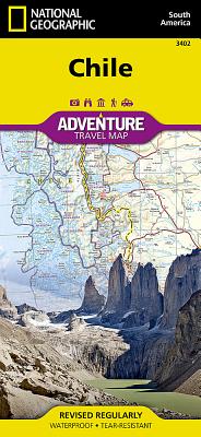
-Waterproof-Tear-Resistant-TravelMapNationalGeographic’sChileAdventureMapistheperfecttravelcompanionforadventuretravelersexploringthislongandnarrowcoastalcountryoccupyingmuchofSouthAmerica’sPacificcoastline.Expertlyresearched,themapcombinesunparalleleddetailwithauser-friendlydesign,includingahandyindexoftowns,citiesandNationalParksandReserves,tohelplocatethemquickly,aswellasaclearlymarkedroadnetworkofhighways,majorandminorroads,andunpavedroads,labeledwithdistances.Inaddition,hundredsofwell-knownandoffthebeatenpathcultural,historicalandrecreationalpointsofinterestarehighlighted,includingUNESCOWorldHeritageSites,archeologicalsites,beaches,lighthouses,monuments,churches,spasandareasforskiing,fishingandsurfing.Outdooradventurerswillfindmappedhikingtrailsalongwithsuchtopographicfeaturesascontourlines,elevationsandlabeledpeaks.Themapconvenientlycoversthecountryinfoursections:fromitsnorthernborderswithPeruandBoliviatothecityofCopiapo;thenextsectioncontinuessouth,throughthecapitalofSantiago,toConcepcion;thenintoPatagoniaandthecityofCoihaique,theChonosArchipelagoandMoraledaChannel;finallytothesouthernmostpartofthecountrywithitsNationalParksandPreserves,includingAlbertodeAgostiniNationalPark.ThelongborderwithArgentiaisshownwithbordercrossings.InsetmapscoverEasterIslandandtheJuanFernandezIslands.Thisuniquemap,withitsabundanceofspecializedcontent.complimentsanyguidebook.EveryAdventureMapisprintedondurablesyntheticpaper,makingthemwaterproof,tear-resistantandtough--capableofwithstandingtherigorsofinternationaltravel.MapScale=1:1,750,000SheetSize=37.75“x25.5“FoldedSize=4.25“x9.25“